


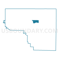
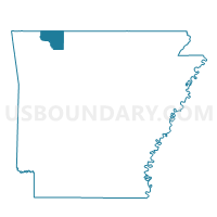
Prairie NE Voting District, Carroll County, Arkansas
About
Outline

Summary
| Unique Area Identifier | 526061 |
| Name | Prairie NE Voting District |
| County | Carroll County |
| State | Arkansas |
| Area (square miles) | 5.26 |
| Land Area (square miles) | 5.26 |
| Water Area (square miles) | 0.00 |
| % of Land Area | 100.00 |
| % of Water Area | 0.00 |
| Latitude of the Internal Point | 36.38464320 |
| Longtitude of the Internal Point | -93.52613000 |
Maps

Graphs
Select a template below for downloading or customizing gragh for Prairie NE Voting District, Carroll County, Arkansas


Neighbors
Neighoring Voting District (by Name) Neighboring Voting District on the Map
- Berryville Ward 1, Carroll County, AR
- Berryville Ward 2, Carroll County, AR
- Hickory NW Voting District, Carroll County, AR
- NW & SW Prairie Voting District, Carroll County, AR
- Polo Voting District, Carroll County, AR
- Prairie SE Voting District, Carroll County, AR
Top 10 Neighboring County Subdivision (by Population) Neighboring County Subdivision on the Map
- Prairie township, Carroll County, AR (7,555)
- Hickory township, Carroll County, AR (4,977)
- Polo township, Carroll County, AR (1,224)